|
LITHUANIAN QUARTERLY JOURNAL OF ARTS AND SCIENCES
|
ISSN
0024-5089
Copyright © 2007 LITUANUS Foundation, Inc.
|
|
Volume 53, No 4 - Winter 2007
Editor of this issue: Violeta Kelertas
|
|
VILNIUS ON THE MAP OF SARMATIA: I
Laimonas Briedis
LAIMONAS
BRIEDIS is a native of Vilnius, but was educated in
Canada. PhD in Geography in 2005, University of British Columbia.
Currently, postdoctoral fellow at the University of Toronto, History
Department. His first book Vilnius: City of Strangers is due to be
published
in winter of 2008 by Baltos Lankos, Vilnius. He lives between
Vancouver and Vilnius.
Whoever
pronounces the word center
implies another word,
periphery,
and a relationship between the two, either centrifugal
or centripetal. Also, a center implies crossing lines, vertical and
horizontal. These few elementary notions about space should
be present in our mind when we deal with the geography and
history of Europe taken as a whole, and particularly of socalled
Eastern Europe. Perhaps coming from an area which for
a long time has been considered the Eastern marches of Romecentered
Christendom makes one more sensitive to shifting
points of gravity, symbolized by the very fluidity of such terms
as the West
and the East.
Czesław
Miłosz
The metaphor and name of Europe has
its origins in ancient
Greek mythology, but the idea of Europe as a geographical unit
places its origins in the visualization of the Christian realm of
the Renaissance period.1
In the sixteenth
century, the name of
Europe began to appear regularly on the title pages of various
maps and atlas collections. At the same time, through various
artistic representations of Greek myths, the idea and representational
character of Europe also entered the aesthetic and
cultural terrain of the period. John Hale, in his elegant study of
Renaissance Europe, described this parallel evolution of cartographical
imagination and aesthetic practices as an intellectual passage:
“From myth and map, chorography, history and survey,
Europe passed into the mind.”2
By the 1600s, the symbolic meaning of
Europe became
inseparable from its geographical body. Surrounded and safeguarded
by water on three sides, Europe gradually dissolved
into the vast landmass of Asia. In general, early maps of Europe
did not show bias towards the western parts of the continent.
The maps, according to Hale, devoid of “indications of
political
frontiers … were not devised to be read politically. And the
busily even spread of town names did not suggest that western
[Europe] had any greater weight of economic vitality than
eastern Europe. This even-handed appearance of uniformity
owed something to the cartographer’s horror vacui, but more
to their places of work and the networks of correspondents
[...] radiating from them.”3
Most maps were produced in the
northwestern parts of Europe with intense commercial, religious,
and political connections with the Baltic Sea region. As
a result of these networks, neither “cartographers nor
traders
thought of Europe as comprising an ‘advanced’
Mediterranean
and a ‘backward’ Baltic, or a politically and
economically sophisticated
Atlantic West and a marginally relevant East.” 4
Vilnius, the capital city of one of
the largest political entities
in Europe, was recognized as geographically equal to any
important urban center of western and southern Europe. The
city’s cartographic visibility was also sharpened by the
relative
representational emptiness of its hinterland. There were
fewer towns in Lithuania than in other parts of Europe, and
except for vast forests and swamps, there were no other significant
topographical elements – mountains, large rivers or lakes,
etc. – to be mapped out. Indeed, the cartographers of the
early
Renaissance often exaggerated the topographical features
of Lithuania. The rolling, undulating landscape around the
city
was portrayed in a similar fashion to the mountainous regions
of the Carpathians, swampy areas of the Lithuanian-Byelorussian
lowlands frequently appeared as immense lakes equal in
size to uncharted seas, and minor rivers were delineated as
gargantuan waterways.5
Vilnius’s magnified
presence was also directly linked to
the political conception of Lithuania as a geographical frontier
of European civilization. In (western) Europe, the dynastically
unified state of Poland-Lithuania became widely recognized as
“a steadfast fortress … against the Turks and
Crimean Tatars …
[and] against those other westward-pressing
‘barbarians’, the
peoples of Russia, from the Muscovite heartlands around the
capital to the semi-independent Cossacks of the South.”6 This
habitual location of Lithuania stimulated not only the Western
European geographical imagination (which populated the
country with exotic natural phenomena, strange peoples and
bizarre local history), but also contributed to “the
production
of such masterpieces of devoted cartography as Mikolaj
Radziwill’s
Duchy of Lithuania of
1613.”7
The detailed map, commissioned
by Mykolas Radvila (Mikołaj Radziwiłł), a cosmopolitan
scion of one of the wealthiest families of the Lithuanian nobility,
depicted the vast region stretching from the shores of the
Baltic Sea to the central areas of Ukraine. The map ushered the
Renaissance practice of accurate cartographical workmanship
into the aesthetically mannered era of Baroque rationalism. It
became a model of precision and stylistic refinement for generations
of European mapmakers. On this map, Vilnius (or Vilna,
as it appears on the map) takes center stage not only because of
its representational prominence within the hierarchical system
of cartographical legend as the main city of Lithuania, but
also because the geographical spread of the covered region
seems
to
be consciously centered around the city.
The earliest known map of Vilnius was
made in 1513 on
a chart entitled Tabula
moderna Sarmatia, exactly one hundred
years before the appearance of Radvila’s map.8 According
to
the cartographic legend of the map, this modernized chart of
Sarmatia was a revised replica of an earlier map of Sarmatia
made by a cardinal and governor of Rome, Nicolus Cusanus
(1401-1464), which was printed in Strasburg in 1491 with the title
of Sarmatia terra in
Europa. Both maps of Sarmatia were published
as updates of the classical work of Ptolemy’s Geographia.
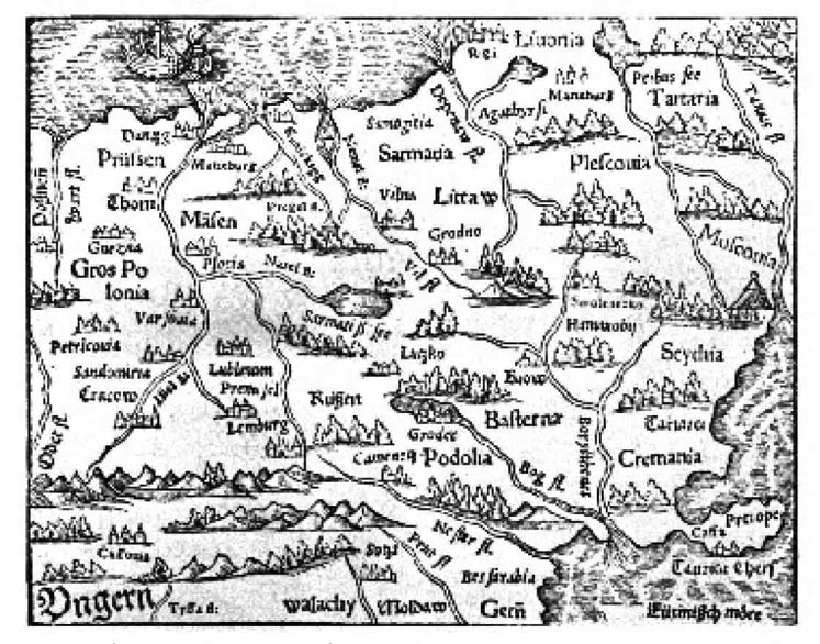 |
Map of Central Europe from Sebastian
Münster’s “Cosmographia
Universalis,”
Basel 1552. This map shows the area of Sarmatia and Littaw
(Lithuania)
as well as Vilna (Vilnius) and the river Nemel (Nemunas).
See the article
“Vilnius on the Map of Sarmatia: I” on p. 23. |
Ptolemy’s original map of
Sarmatia specified only natural
and ancient ethnographic features of the region – it
delineated
rivers, seas, mountains and local barbarian tribes. In contrast,
Cusanus’s version clearly outlined contemporary contours of
Sarmatia by mapping out the recognizable countries of Hungary,
Poland, Russia, Prussia and Wallachia – the geographical
equivalent of the modern region that falls under the broad
category of east-central Europe. The Grand Duchy of Lithuania
also appears, for the first (known) time, on the 1491 copy of
Sarmatia; yet its capital city is identified only as an unnamed
cartographical spot. Clearly, the 1513 copy attempts to rectify
the cartographic obscurity of Lithuania by sprinkling its territory
with several named and well-marked towns. Ironically,
the cartographers were so enthusiastic in populating Lithuania
with numerous cities and castles that they recorded Vilnius
twice on the same map.
The first record correctly identifies
the Lithuanian capital
as the town of Wilno
by situating it at the confluence of two (unnamed)
rivers. The second record incorrectly marks the city as
Bilde
located south of the original Wilno.
The name Bilde,
which
has no known historical equivalent, appears to be a corrupt
version of the place name Wilde,
occasionally used to identify
Vilnius in several German-language descriptions of
Lithuania of the fifteenth and sixteenth centuries. The German
usage of
Wilde as a
name for Vilnius (as in die
Statt Wilde, für die Wilde,
zur Wilde) stems from fourteenth century chronicles of the
Teutonic
Order, a crusading monastic organization whose primary
ideological and geopolitical prerogatives were the conquest
and Christianization of pagan Lithuanians.9
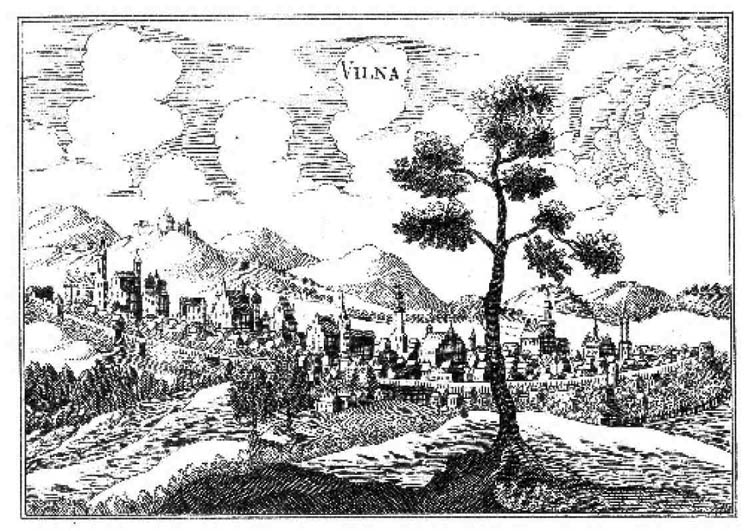 |
View of Vilnius in the Early 17th century.
Lithograph by Ch. Barousse
(19th
c.) after T. Makowski. Copper engraving. |
Place name misnomers were not unusual
in the earlier
European chronicles (or for that matter in the colonial records
of European empires), and in the frontier-like environment of
Lithuania, vernacular names were subject to a great variety of
misspellings and linguistic alterations. Yet the orthographic affinity
of Wilde
to Wilna
(or Vilnius) probably has something to
do with the ideological, and in this case, geo-religious struggle
over control of Lithuania. The German word Wilde has very
specific connotations: der/die
Wilde means savage or wild. The
vast forested territory which separated Vilnius from the Teutonic
Knights’ possessions in Prussia was depopulated due to
the endless raids of the crusaders and was simply referred to
in German as die
Wildnis – the wilderness. The crusaders called
their regularized military expeditions into pagan Lithuania
reysen, an adventurous excursion into a feral territory similar
in spirit, if not tactics, to an aristocratic hunting party10
Throughout the fourteenth century,
despite being concentrated
on the eastern fringes of the Baltic Sea, the warfare between
the Teutonic Knights and Lithuanians resonated all over
Catholic Europe. The continuous crusades were ordered by the
pope, and among the arriving crusaders there were:
Bohemians
in 1323, Alsatians in 1324, Englishmen and
Walloons in 1329, Austrians and Frenchmen in 1336. John of
Bohemia made three trips, as did John Boucicaut and Count
William IV of Holland, Henry of Lancaster went in 1352. Henry of Derby,
the future King Henry IV of England, went in 1390 and
1392. In 1377 Duke Albert of Austria came with 2,000 knights
for his ‘Tanz mit den Heiden’ (Dance with the
Heathen). In the
following year the duke of Lorraine joined the winter reysa with
seventy knights. Shortly after this Albert of Austria turned up
again with the Count of Cleves and they had a special reysa
laid out for them so that they could fulfill their vows before
Christmas. Count William I of Guelderland went seven times
between 1383 and 1400.
The
winter reysa
was a chevauchée
of between 200 and
2,000 men with the aim simply of devastating a given area as
quickly as possible. There were usually two of these a year,
one in December, the other in January or February, with a gap
between the Christmas feast. The sommer-reysa
was usually
organized on a large scale with the intention of gaining territory
by destroying an enemy strongpoint or building a Christian
one, although plundering was a feature too. These reysen were
not unlike sports, subject to the weather conditions in much
the same way as horse-racing is today ... Were it not for the
brutality and the very real hardships, one is tempted to write
of the reysen as packaged crusading for the European nobility,
and their popularity demonstrated how attractive this package
could be when wrapped in the trappings of chivalry. But they
depended on the existence of a frontier with paynim and an
infidel enemy which could be portrayed as being aggressive.11
Vilnius, which was unsuccessfully
stormed by the crusaders
several times, entered the European geographical consciousness
during this century of perpetual reysen.12
The medieval perception of the city
was no doubt
augmented
by the factual religious beliefs and practices of local
pagan people, who worshiped natural phenomena, such as the
sun, the moon, thunder, animals, and especially, trees and
the forest. According to numerous historical records and
archaeological
evidence, the most important pagan Lithuanian shrine
was located at the historical heart of Vilnius – the
confluence
of the two rivers, Neris and Vilnia – and was protected by a
sanctified oak grove. Since ancient Greek and Roman times, the
Western European social and cultural comprehension of urban
spatiality has always been associated with a clear symbolic
and very often physical separation between the natural and
the civic worlds. This eccentric toponym of Wilde
“organically”
positioned the city outside urban (Christian) Europe: it made
it a defining element of the Lithuanian wilderness. It should
not come as a great surprise that once the Lithuanian elite accepted
Christianity in 1387, the second religious act after the
actual baptism conducted by the Catholic missionaries was the
formalized cutting down of the sacred forest.
The representational schism of
Vilnius on the updated
map of Sarmatia was most likely only a cartographic echo of
the pagan past of the city; and soon, Bilde vanished from
the
Renaissance face of Europe. The name Wilde, however,
lingered
for another century or two within various Western European
annals of Lithuania, and its corrupt forms could still
be found in French geographical records up until the beginning
of the seventeenth century. This sporadic usage of Wilde
by various European commentators was usually an indication
of the author’s geographical ignorance, because by the time
of
the Baroque period, at least among more knowledgeable mapmakers
and chroniclers, usage of more accurate place name
forms for the city were common. But the perception of Vilnius
as an urban frontier of the Lithuanian (or European) wilderness
survived, and even in the modern era, many people have
still commented on the spatial intimacy between the town and
surrounding nature.
For example, Jan Bułhak (1876-1950),
the most celebrated
photographic recorder of twentieth century Wilno, summarized the
topographical layout of the city with a simple but
pictorially accurate statement: “A deep hollow with two
rivers
and forty temples, almost all covered over by hills and flooded
by a sea of greenery – this is a typical description of
Wilno.”13
In a more experiential fashion, an American visiting the city in
the late 1930s described a train arrival into the city as a journey
deeper into the wilderness:
It
seemed entirely in accord with our preconceived notions of
Russian Poland that, awaking early in the morning and peering
through the windows of our sleeping car, we should behold
dense forest of pine, fir and hemlock stretching away from both
sides of the railway track. The moving panorama was the exact
counterpart of the picture we had so frequently seen of the
lonely evergreen wilderness of Poland and Russia, save for the
absence of the inevitable sleigh stalked by famished wolves.14
Even a plane landing in contemporary
Vilnius evokes
among some of its more recent visitors a sense of being plunged
into the realm of natural isolation. “The further east the
plane
flew,” notes a South African passenger, Dan Jacobson, who
visited
the city in the 1990s,
the
less demarcated the landscape became, the fewer were
the roads crossing it, the more rarely were vehicles to be seen.
Ploughed fields turned into pasture lands, pastures into woods,
woods into water, water into tussocky heaths and marshes. Each
change was marked by a simple, limited change of color. No one
appeared to be moving in the villages randomly dotted about.
There were no mountains; hardly any hills ... The place looked
almost as empty after we landed as it had from above.”15
If in post-Renaissance Europe, the
name Wilde
gradually
faded from continental charts, then the name Sarmatia gained
in strength as a mythopoetic equivalent of the Polish-Lithuanian
geographical body. Indeed, the Baroque era imagination
substantiated Sarmatia with a remarkable sense of cultural, political
and social reality. In this sense, Sarmatia was foremost a
province of Baroque mannerism, a spatial paradox suspended
somewhere between narrative illusion and geographical
reality.
The cartographic origins of Sarmatia
could be traced
back to the geographical and historical works of the ancient
Greeks and Romans. Reputedly, Ptolemy situated the barbarian
tribe of the Sarmatians somewhere in the steppes between
the Azov and the Caspian Sea. Herodotus and other commentators
moved the semi-nomadic Sarmatians westwards to the
area of the Black Sea and the lower basin of the Dnieper River.
Some time later, this tribe of permanent wanderers was moved
further north to the region where the vast southern steppes and
plains of Eurasia meet the northern forest and marshlands of
the Baltic Sea littoral. According to Tacitus, this was an unexplored
land somewhere near the “Suabian Sea” (most likely,
the Baltic Sea) where “our knowledge of the world
ends.”16
Centuries later, some time in the early part of the fifteenth century,
this barely mapped-out land of the southeastern coast of
the Baltic Sea was resurrected as Sarmatia
terra in Europe. The
sea itself acquired a Sarmatian identity and was often identified
on the maps of Europe as Mare
Sarmaticum.
Undoubtedly, the historical
reputation of the region as
the area inhabited by some of the last pagan peoples in Europe
strengthened the mapmaker’s case for locating the land
of ancient, barbaric Sarmatians along the Baltic Sea coastline.
By the mid-sixteenth century, the Renaissance desire to bring
geographical and ethnographical information found in ancient
texts and maps into the contemporary spatial purview
of Europe put Sarmatia into a cartographic limbo. The region
had already been divided into several countries, such as Prussia,
Lithuania (and Samogitia), Livonia and Poland, and there
simply was no space for the ancient Sarmatians to dwell in between
these clearly demarcated political entities. As compensation
for this political impasse, the Sarmatian cartographic image
was stretched farther so it could accommodate its historical
and contemporary elements. This made Sarmatia an extremely
elastic and elusive entity, with a variable geographical shape
and constantly shifting boundaries. In the end, Sarmatia’s
exact
geographical location was never reliably mapped out. Not unlike
its tribal forefathers, who roamed between the known and
unknown realms of the ancient world, “modern”
Sarmatia was
a nomadic entity.
Indeed, on many maps of the Baroque
period, Sarmatia
was the only European country that had its geographical
doppelgänger in Asia, Sarmatia
Asiatica. The European part of
Sarmatia was controlled by Christian rulers – the Asian side
dominated by Muslims. (In this sense, Sarmatia was an early
cartographical embodiment of the modern idea of Eurasia.)
Moreover, since not every map of Europe even carried the name
of Sarmatia, the dissected land of the Sarmatians acquired a
phantom existence. The country and its people periodically appeared
on the maps of Europe only to vanish again.
This ethereal existence of Sarmatia
was made more corporeal
by the emergence of Sarmatism, a peculiar sociocultural
milieu that found a fertile ground among the Polish-Lithuanian
nobility of the sixteenth century. The Polish-Lithuanian Commonwealth
was one of the largest countries in Europe, stretching
at the time from the Baltic to the Black Sea. Its nobility, like
most elite societies of Europe, enjoyed an elaborate Renaissance
sense of spectacle. Local theatrical rituals “exhibited
typical
Polish traits despite being founded on a common European
practice which derived from ancient Greek and Roman tradition,
later enriched by Roman Catholic liturgy and the ceremonies
displayed in the courts of feudal monarchs throughout
medieval Europe, as well as by some Oriental influences.”17
It was through such lavish representational fusions that
Sarmatia
passed from the cartographic Theatrum of the Renaissance
mind into the sociopolitical stage of the Baroque age.
Sarmatism resulted from a fusion of
regional patriotism
with the rediscovery of classical Greek and Roman maps and
texts. Although Sarmatism was based on ancient geo-mythology,
it “was a unique variation of what might be called
Renaissance
national self-definition. In the Renaissance spirit of a return
to sources, the peoples of Europe searched for or created
their own (mythic) origins. Sarmatism expressed for the Poles
the idea that, like other European nations, they too had their
origins in the peoples discussed by the authors of antiquity, but
their ancestors were even older than some of those claimed by
many other Europeans.”18
And if the Renaissance turned Sarmatism
into a political (national) ideology, then Baroque made
it a cultural (social) phenomenon.
Baroque emerged in Rome, but within a
few decades,
this new artistic style captured most of Europe. In the northcentral
parts of Europe, the dispersion of Baroque sensualities
followed the jagged military movements of the Thirty Years
War (1618-1648), which, by pushing massive armies endlessly
across national frontiers, contributed to the decimation of the
region.19
In Poland-Lithuania, this war was followed by what
later historians called the Deluge (1648-1667), a cycle of massive
foreign invasions, from the Swedes to the Ukrainian Cossacks
and from the Ottomans to the Muscovites. The Commonwealth
never truly recovered from this upswing of war and mass death.
Under such circumstances, the cultural orientation of the Baroque
towards the center of the Catholic world – Rome –
proved
to be quite popular in Poland-Lithuania, which, since the fall
of Constantinople in the fifteenth century, had acquired the
title
of
the antermurale
christianitatis, the bulwark of Christendom.
By the middle of the seventeenth
century, the Commonwealth
was already a ruined fortress. It could never defend its
own borders, not to mention the imaginary or geopolitically
constructed boundaries of Europe. Out of this military inability
came a mythological orientation of Sarmatism that reached
its sociocultural heights at the end of the seventeenth century.
More precisely, the apogee of Sarmatism corresponded with the
glorious delivery of Vienna from the Turkish siege by the Polish-
Lithuanian forces in 1683. For the Commonwealth, the political
spoils of victory were short-lived, because the country’s
prestige in Europe had already been significantly damaged by
a series of military defeats and debilitating social, economic
and natural disasters. Paradoxically, after one of the most significant
victories in the centuries-long struggle of the European
Christian states with the Ottomans, having “lost all hope
of salvation, Polish society turned in on itself and, bewitched
by the imaginary ideals of ‘Old Sarmatia’, began to
lose sight
of elementary realities.”20
By the beginning of the eighteenth
century, during the so-called Saxon era (1697-1764), when the
Commonwealth was ruled by two foreign monarchs (the electors
of Saxony), Sarmatism acquired its explicit qualities of nostalgic
inwardness and sentimental isolationism.
The surprising result of this
self-imposed and imagined
Sarmatian seclusion – after all, the country continued to be
occupied and plundered by various foreign (Swedish, Russian,
Saxon, etc.) armies – was the creation of a cultural and
architectural opulence unmatched in the history of the Commonwealth.
The Baroque synthesis of splendor and ruin, best
exemplified in the celebratory and/or rhetorical elaborations
of funerary processions and architecture, provided the most
impressionable answer to the seemingly senseless succession of
plundering armies. Amidst this commonplace routine of
victories and defeats, liberations and conquests, and life and
death, the perceptual distance between beauty and decay was
erased. Numerous foreign glories brought national catastrophes
to Lithuania, but the military destruction of the country
was often followed by the impulsive rebuilding of its urban
relics. The transitory moments of life were celebrated through
a topographical profusion of Baroque aesthetic splendor. Thus,
while the local “economy stagnated” and
“towns shrank […]
the opera and theater flourished. The parks, the architecture,
and the music were superb. All the arts found ample
patronage.”
21
Naturally, churches were the first to be rebuilt, since
they could serve both as monumental tokens of thanksgiving
and elaborate spaces for holding the crypts and tombs of the
elite.
Below the aristocratic cosmopolitan
affluence and geopolitical
indifference, there were some attempts to reconcile the
ruinous state of the country with the notorious provincial
traditionalism
of the local nobility. As a result, “Polish Sarmatism,
the characteristic style of the Saxon era, wallowed in the
sentimentality
of the Republic’s alleged glories and achievements,
and is generally thought to have little literary or artistic merit.
Allied to the fashion for oriental dress and decoration, it reinforced
the conservative tendencies of the Szlachta
[the nobility]
and the belief in the superiority of their “Golden
Freedom” and
their noble culture.”22
By the time of enlightenment absolutism
– the middle of the eighteenth century – Sarmatism
turned
into a twofold structure. On the surface, it displayed eccentric
features of crafty Rococo splendor and vitality, but underneath
this visual grandeur, there was a melancholic awareness of inevitable
loss and decay.
Looking back from the contemporary
perspective of the
cultural and/or political irrelevance of Sarmatism, it is easy to
forget that this semi-mythical milieu was an expression of a
very strong national identity united through clearly defined
social bonds and territorial loyalties. Sarmatia, despite its fluid
historical and vaporous geographical nature, was not a vacuous
space. It was filled with an unfolding array of people, objects
and gestures that visibly demarcated its cultural and even
political dimensions. Although the original Sarmatians, like the
Goths, Vandals and Huns, had left the space of Europe a long
time ago, their blood and heritage were thought to have created
a distinct social-cultural milieu of the Polish szlachta. In this
sense, the Polish and Lithuanian nobilities often envisioned
Sarmatia as a palimpsest with endless genealogical inscriptions
and family ties. The porous borders of the Commonwealth
played an important role in shaping the peculiarities of the Sarmatian
culture. And while many “practices stemmed from the
expressiveness of the pan-European Baroque ... they developed
unique forms in the Polish-Lithuanian Commonwealth in part
because of its extensive contact with Russian and Ottoman
civilization.”
23
Various daily rituals, official ceremonies, habitual
gestures, oratorical diatribes and of course language, kept the
Sarmatian nation of the Polish-Lithuanian nobility apart from
other surrounding nations, such as Saxons, Prussians, Swedes
and Russians. The Polish szlachta
wore specific Sarmatian garments,
followed unique Sarmatian social and religious practices,
and even suffered from a bizarre local medical pathology,
explicitly identified in Latin as plica
Polonica.24
The fictionalized image of Sarmatia
was supported by the
theatricality of Baroque imagination, which freely mixed ancient
epics, biblical scenes, exotic locations, fantastic motifs and
contemporary European political events into an unfolding spatial
drama. Still, Sarmatism was a modern phenomenon, for its
national distinctiveness relied heavily on the imagined coherence of a
diverse ethno-social community. Nobles comprised
about 10 percent of the total population of Poland-Lithuania
– it
was probably the largest and most privileged noble class in Europe.
(In most western European countries, the nobility consisted
of fewer than 5 percent of the population.) On the other
hand, the nobility of the Commonwealth was neither culturally,
linguistically and/or economically homogenous: it comprised
families of Polish, Lithuanian, Ruthenian, Russian, Tartar, German
and some other foreign origins. It also included adherents
of the Catholic, Protestant, Orthodox, Uniate and even Muslim
religions. Among the nobles, there were people of various
financial means, from exceptionally wealthy magnates to the
extremely poor landless szlachta. Despite these differences,
the noble families were all united under a public spectrum of
political equality and social brotherhood. Sarmatism not only
framed this diverse body through specific political practices,
but also served as a culturally connecting thread. The everyday
practice of Sarmatism celebrated and empowered the local
nobility, which understood its social and geopolitical role
as a messianic duty to protect its own rights and privileges.
The Polish-Lithuanian nobles were absolutely convinced that
they lived in the best society in the world and attributed this
achievement to the Sarmatian origins of their Commonwealth.
It was also widely believed that Sarmatia reached its golden
age in the sixteenth century, at the time of the Lublin Union,
which in 1569 created the confederate republic of Polish and
Lithuanian nobilities. Hence, in many ways, the nobility’s
conservatism
and “resistance to reform came from love of liberty
and xenophobia.”25
Despite this apparent inner
coherence, in the eyes of European
commentators Sarmatism remained a cultural oddity.
The most bewildering aspect of Sarmatism was its temporal
disharmony, for Sarmatia appeared as both a contemporary
and ancient space, a land of indecisive (historical) erasures and
imprecise (contemporary) inscriptions. Furthermore, while
it was widely acknowledged that Sarmatia implied a spatial and
cultural frontier, it was not clear what lands, or whose territories
and histories it (dis)connected. In short, for enlightened western
Europeans, Sarmatia appeared not so much as a geographical
palimpsest, but as a farcical theatre. In 1784, the French
count de Segur, for instance, described the road from Berlin to
Warsaw as an ethnographical journey in time where “everything
makes one think one has been moved back ten centuries,
and that one finds oneself amid hordes of Huns, Scythians,
Veneti, Slavs, and Sarmatians.”26
The count experienced Warsaw
as a place located “at the extremity of the world,”
where
a passing observer was greeted with a “sort of palace of
which
one half shined with noble elegance while the other was only
a mass of debris and ruins, the sad remains of a fire.”27 On the
southern edges of the expanding Russian empire, somewhere
in the region of the lower Dnieper River – the assumed
original
homeland of the ancient Sarmatians – Segur, on his way from
Saint Petersburg to the Crimea (just recently won by the tsarina
from the Ottomans) again encountered a parade of centuries
and peoples. “It was,” recalled the count
“like a magic theatre
where there seemed to be combined and confused antiquity
and modern times, civilization and barbarism, finally the most
piquant contrast of the most diverse and contrary manners, figures,
and costumes.”28
Within this vast array of centuries
and peoples, it was
easy for most foreigners to overlook the geographical and ethnological
peculiarities of Lithuania. In general, foreign knowledge
of Lithuania was scant and sketchy at best. Few people,
except for the invading armies whose knowledge of the country
was too transitory and predatory, visited the country. Up
until the eighteenth century, many printed cosmographies of
Europe still claimed Lithuania to be a country of
impenetrable woods and endless swamps, inhabited by
uncivilized people
living in close proximity with wild beasts. Occasionally, reports
from more knowledgeable visitors tried to prove otherwise
by stating that while the country was extensively covered
by woods, its natural world was full of exceptional wonders.
In their opinion, the landscape was pleasant enough, and the
forest rich in exotic animals and plants that had become extinct
in more urbane parts of the continent. And although there were
few cities and towns, there was plenty of good and cheap food
to support the country’s largely rural population.
Most visitors, however, agreed on one
point: travelling
in Lithuania required time, patience, and good health, because
bumpy roads, swampy terrain, icy rivulets, unpredictable climate,
uncultivated wilderness, desolate countryside, and a
lack of most travel comforts made a trip a strenuous experience.
Vilnius in particular was difficult to reach. In short spells
of dry weather, mostly in summer, coaches could barely pass
through narrow dusty highways; in most other times, soggy
sandy roads bogged down any movement. Some travellers
suggested making a more comfortable trip in a sleigh during
long winter months. In addition, locals could offer only simple
food and shelter of extremely poor quality, for the area around
the Lithuanian capital was one of the poorest regions in the
entire country. Still, several visitors noted a genuine hospitality
offered by the wealthy magnates of the country which, at least,
for a privileged few, made visiting Vilnius an enjoyable social
pleasure.
Very often foreign accounts compared
Lithuania to Poland,
finding Lithuanian society much more lax in social discipline,
cultural sophistication and sexual morals than its more
westernized counterpart. The (noble) Lithuanians were periodically
described as sluggish drunkards who enjoyed neverending
hunting and opulent dinner parties. Some travellers
also reported an unusually high degree of tolerance regarding
the accepted norms in gender relations and sexual practices. The wives
and daughters of the Lithuanian noble families were
described as being as interested in sex as their husbands and
fathers. According to some occasional reports, many unmarried
women in Lithuania were allowed to freely engage in
sexual activities, and even after their marriage, they were permitted
to keep lovers with the consent of their husbands. So
if the Lithuanian males were often depicted as louts engaging
visitors with their unsophisticated bravado, then local women
were portrayed as sirens seducing travellers by their highly
cultivated amorousness.
Satirical poems and anecdotal jokes
about lewd Lithuanian
women were very common among the Poles, who had
a much closer and more intimate relationship with the Lithuanians
than any other people of Europe. Early printed accounts
describing the Lithuanian practice of matrimoniae adiutores appeared
in Polish and German manuscripts of the late medieval
period, and, in later centuries, they regularly surfaced within
various Western European chronicles. An English version of
such an account was reprinted in 1611 in the cosmographic text
written by J. Boemus in Latin, a few decades earlier. This geographical
book, entitled The
manners, lawes and customs of all nations,
states that Lithuanian women “have their
chamber-mates
& friends by their husband permission, & those they
call helpers
or furtherers of matrimony, but for a husband to commit
adultery is held disgraceful and abominable: Marriages there
be very easily dissoluted, by consent of both parties, and they
marry as oft as they please.”29
It is hard to know how accurate
the descriptions of Lithuanian sexuality were, since most cosmographies
of the Baroque era meant to entice readers with
scandalous stories of barbarous lust and exotic gender characteristics.
It is also not known whether foreign visitors based
their reports of the sexual practices of Lithuanian women on
their personal experience or on gossip gathered while travelling
through the country. However, one thing is clear, by the
standards of the time, Lithuanian (noble) women had many
more social and economic rights than their western European
counterparts, officially enshrined in the legal code of dukedom,
the Lithuanian Statute. This fact alone might suffuse the unverifiable
statements concerning the sexual practices of Lithuanian
society with a certain degree of cultural legitimacy.30
(To be continued)
Continued in our Vol 54:1, Spring 2008 issue
1. Wilson and Dusten, 1993.
2. Hale, 1994, 38.
3. Ibid., 20.
4. Ibid.
5. On the early history of the cartography of Lithuania, see
Vaitekūnas,
1997; also Maksimaitienė, 1991.
6. Hale, 1994, 24.
7. Ibid.
8. Gudienė, 1999.
9. On historical variations of the name Vilnius, see
Jurkštas, 1985; Toporov,
2000; Vanagas, 1993.
10. On the Teutonic Order, see the works of Urban, 1975, 1989, 2003.
11. Riley-Smith, 2005, 253.
12. Chaucer captured the European scope of the crusader’s
reysa
against pagan Lithuanians in the passage of Canterbury Tales
depicting
the adventures of the Knight, who: “Full often time he had
abroad bygone / Above all nations, to Prussia. / In Lithuania had he
reysed and in Russia / No Christian man of his degree more
often.”
Roy, 1999, 69
13. Markevičienė, 1999, 104.
14. McBride, 1983, 111-112.
15. Jacobson, 1999, 109.
16. Davies, 1982, 45.
17. Bogucka, 1996, 36.
18. Kaufmann, 1995, 288.
19. Munck, 1990, 81-108.
20. Davies, 1982, 367.
21. Ibid., 508.
22. Davies, 2001, 265.
23. Stone, 2001, 211-213.
24. For more information on the Sarmatian style, see
Matuškaitė, 2003,
95-222; Martinaitienė, 2001, 165-175.
25. Stone, 2001, 211-212.
26. Ségur, quoted in Wolff, 1994, 19.
27. Ibid., 20.
28. Ibid., 130.
29. Joannes, 1611, 221-222.
30. For more on the foreigners’ views on Lithuania see
Kamutavičius,
2002.
42
WORKS CITED
Bogucka, Maria. The Lost World of the
‘Sarmatians.’ Warszawa: Polish
Academy of Science, Institute of History, 1996.
Davies, Norman. God’s Playground: A
Hostory of Poland, vol. 1. New
York: Columbia University Press, 1982.
Gudienė, Danguolė, ed. Lithuania on the Map.
Vilnius: Lietuvos nacionalinis
muziejus, 1999.
Hale, John. The Civilization of Europe in
the Renaissance. New York: Atheneum,
1994.
Jacobson, Dan. Heshel’s Kingdom.
London: Penguin Books, 1999.
Jonnes, Boemus. The manners, lawes and customs
of all nations with many
other things.... London: 1611.
Jovaiša, Liudas and
Tumelis J., eds. Visitatio
dioceses Samogitiae (A. D.
1579)/ Žemaičių vyskupijos vizitacija. Vilnius: Mokslas,
1998.
Jurkštas, Jonas. Vilniaus vietovardžiai.
Vilnius: Mokslas, 1985.
Kamutavičius, Rustis.
“Lietuvos įvaizdžio stereotipai italų ir prancūzų
XVI-XVII a. literatūroje.” Ph.D dissertation. Kaunas: Vytauto
Didžiojo Universitetas, 2002.
Kaufmann, Thomas Da Costa. Court, Cloister and City: The Art and
Culture
of Central Europe, 1450-1800. Chicago: University of
Chicago
Press, 1995.
McBride, Robert Mediil. Towns and Peoples of Modern
Poland. New
York: McBride and Company, 1938.
Maksimaitienė, Ona. Lietuvos istorinės geografijos
and kartografijos bruožai.
Vilnius: Mokslas, 1991.
Markevičienė, Jūratė.
“Genius Loci of Vilnius.” Vilnius: Lithuanian Literature,
Culture, History, Summer 1999.
Martinaitienė, Gražina Marija.
“At the Crossings of Western and
Eastern Cultures: the Contush Sashes.” Lietuvos Didžiosios
Kunigaikštystės
barokas: formos, įtakos, kryptys, Acta Academiae Artium
Vilnensis 21, 2001.
Matušakaitė, Marija. Apranga XVI-XVIII a. Lietuvoje.
Vilnius: Aidai,
2003.
43
Miłosz, Czesław. “Looking
for a Center: On the Poetry of Central
Europe.” Beginning
with My Streets: Essays and Recollections.
Translated by Madeline G. Levine. New York: Farrar, Strauss
and Giroux, 1991.
Munck, Thomas. Seventeenth Century Europe:
1598-1700. London: Macmillan,
1990.
Riley-Smith, Jonathan. The Crusades: A History. New Haven, Yale
University
Press, 2005.
Roy, James Charles. The Vanished Kingdom: Travels
Through the History
of Prussia. Boulder: Westview Press, 1999.
Stone, Daniel. The Polish-Lithuanian State,
1386-1795. Seattle: University
of Washington Press, 2001.
Titunik, I. R.
“Baroque,” Handbook
of Russian Literature, Victor Terras,
ed. New Haven: Yale University Press, 1985.
Toporov, Vladimir.
“Vilnius, Wilno, Vil’na: miestas ir mitas, Baltų
mitologijos
ir ritualo tyrimai.” Vilnius: Aidai, 2000.
Urban, William. The Baltic Crusade.
Dekalb: Northern Illinois University
Press, 1975.
_____. The Samogitian Crusade.
Chicago: Lithuanian Research and Studies
Center, 1989.
_____.The Teutonic Knights:
A Military History. London: Greenhill,
2003.
Vaitekūnas, Stasys.
“Lietuviškosios kartografijos istorijos
bruožai,”
Lietuvos sienų raida,
vol 2., Algimantas Liekis, ed. Vilnius: Lietuvos
mokslas, 1997.
Vanagas, Aleksandras.
“Miesto vardas Vilnius,” Gimtasis Žodis, Nr.
11(59), Novembr, 1993.
Wilson, Kevin and Jan van der Dusten,
eds. The History of the
Idea of
Europe. London: Routledge, 1993.
Wolff, Larry. Inventing Eastern Europe: the Map of
Civilization on the Mind
of the Enlightenment. Stanford: Stanford University Press,
1994.